Memorial Day weekend marks start of summer operations on Blue Ridge Parkway
Read full article: Memorial Day weekend marks start of summer operations on Blue Ridge ParkwayWith many campgrounds, picnic areas and visitor centers opening on the Blue Ridge Parkway this weekend, the National Park Service reminds visitors to plan ahead for a memorable experience.
Blue Ridge Parkway leaders set to provide update on storm recovery efforts
Read full article: Blue Ridge Parkway leaders set to provide update on storm recovery effortsBlue Ridge Parkway leaders are slated to provide an update on storm recovery efforts following the significant damage caused by Hurricane Helene.
Coal dust: Former mine managers face fraud trial in Kentucky
Read full article: Coal dust: Former mine managers face fraud trial in KentuckyA criminal fraud trial in Kentucky aims to determine whether four officials of the now-bankrupt Armstrong Coal company skirted federal rules meant to reduce deadly coal dust in underground mines.
:strip_exif(true):strip_icc(true):no_upscale(true):quality(65):fill(FFF)/cloudfront-us-east-1.images.arcpublishing.com/gmg/RVYKBPPCIFG3POSM326ZPBXJ5I.png)
:strip_exif(true):strip_icc(true):no_upscale(true):quality(65):fill(FFF)/cloudfront-us-east-1.images.arcpublishing.com/gmg/LW6UW5OISRDDNN7TZ2DXJWPVKU.png)
:strip_exif(true):strip_icc(true):no_upscale(true):quality(65):fill(FFF)/cloudfront-us-east-1.images.arcpublishing.com/gmg/UXJG2LT4IFG2NGRB7VHZPVZITE.png)
:strip_exif(true):strip_icc(true):no_upscale(true):quality(65):fill(FFF)/cloudfront-us-east-1.images.arcpublishing.com/gmg/2NRIZCVLMVFWPNROMWXUFASSPQ.jpg)
:strip_exif(true):strip_icc(true):no_upscale(true):quality(65)/cloudfront-us-east-1.images.arcpublishing.com/gmg/GJWHUDC2ZFBNFPARB44UKO6F6A.png)
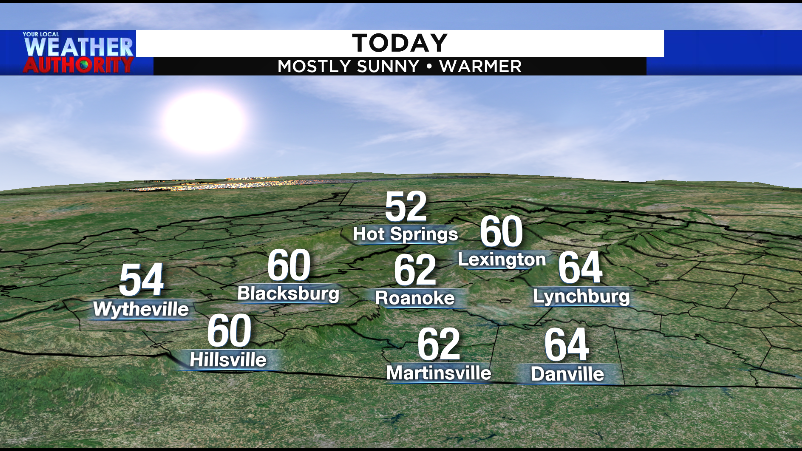
Sunny streak! Temps drop into the weekend despite more sunshine
Read full article: Sunny streak! Temps drop into the weekend despite more sunshineROANOKE, Va. – It rained nearly two-thirds of February this year, so it’s safe to say we’re due for a dry and sunny stretch. In fact, it’s been more than three months since we’ve had a completely dry week. Wednesday continues the dry stretch with temperatures climbing into the upper 50s and lower 60s area-wide. This is also what’s going to help pull down some colder air for the rest of the week and the weekend. What we're tracking for the first weekend of March - 2021Once high pressure moves off the East Coast, we’ll see the return of warmer air next week.
:strip_exif(true):strip_icc(true):no_upscale(true):quality(65)/cloudfront-us-east-1.images.arcpublishing.com/gmg/TYSLYT6L3VE3TJTKCPEYUM3JBE.png)
Tracking a windy warm-up before another wet pattern kicks in
Read full article: Tracking a windy warm-up before another wet pattern kicks inWind speed and wind gust forecast for Tuesday, 2/23/2021This wind, however, works in our favor. High temperature forecast for Tuesday, 2/23/2021Once the wind calms at night, we’ll all fall into the low to mid 30s first thing Wednesday morning. There’s no threat of wintry weather with this front, but we’ll have to see how much cold air is available to us Friday evening. If there’s any chance of wintry weather, it would be in higher elevations west of the Parkway. That’s not to say it will rain 24 hours a day, but it does appear as if another wet pattern will take shape.
:strip_exif(true):strip_icc(true):no_upscale(true):quality(65)/cloudfront-us-east-1.images.arcpublishing.com/gmg/MKVCYQZ44FFKNDQUE6MMRK3PMA.png)
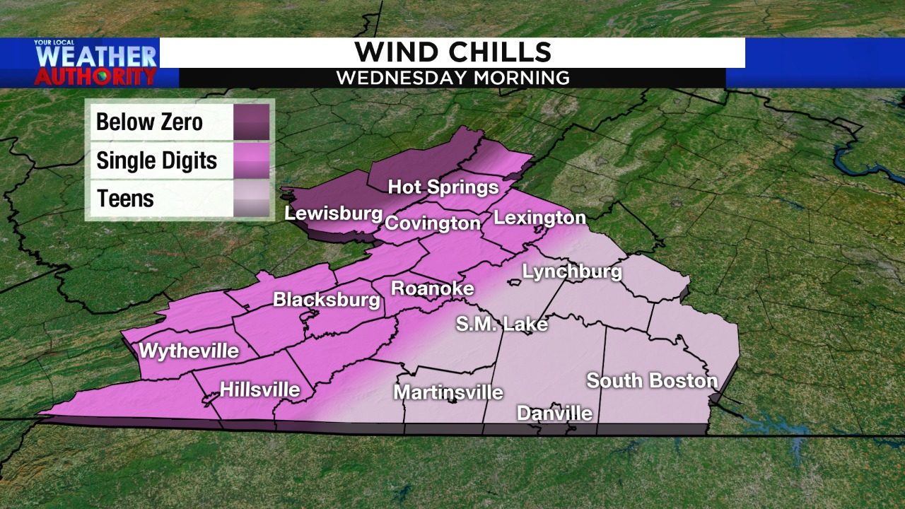
Own that ponytail, work that updo! Wind whips through Wednesday morning
Read full article: Own that ponytail, work that updo! Wind whips through Wednesday morningA Wind Advisory is in effect until Wednesday morning, since gusts could reach as high as 50 mph along and west of the Parkway. Wind advisory in effect through Wednesday morning, 2/3/2021Given how wet the ground is from recent rain and snow, it’s possible that we see some localized tree damage and/or power outages. Wind chills start in the single digits west of Blacksburg and into Floyd County. Wind chills Wednesday morning, 2/3/2021This is just an appetizer for what we expect early next week. Stay with us for updates regarding Sunday’s snow potential and the potential for Arctic air to reach southwest and central Virginia.
:strip_exif(true):strip_icc(true):no_upscale(true):quality(65)/cloudfront-us-east-1.images.arcpublishing.com/gmg/W4IYNMEDQRBGFERP6SSFS2B2NI.PNG)
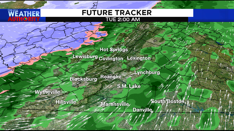
Quick-hitting storm to bring accumulating snow to parts of the region Wednesday night
Read full article: Quick-hitting storm to bring accumulating snow to parts of the region Wednesday nightROANOKE, Va. – We are tracking a storm that’s prompted winter weather alerts for Wednesday night and Thursday morning. Colder air is being drawn into the higher elevations, meaning snow may start as soon as 8 p.m. in the New River Valley. FutureTracker - 8 p.m. WednesdayRecent forecast data indicates that we’ll have a stronger storm to the south, drawing in some colder air Wednesday night. Storm threats from Wednesday night into Thursday morningWhile Thursday will be dry with increasing sun, looks will definitely deceive you. If the storm is farther south and slower, then we could be looking at a wintry mess Sunday into Monday morning.
:strip_exif(true):strip_icc(true):no_upscale(true):quality(65)/cloudfront-us-east-1.images.arcpublishing.com/gmg/C4PUNIH2BNCG3FUK6EJM4QXC7Q.png)
Enjoy a cold and calm weekend before Monday turns all soggy on us
Read full article: Enjoy a cold and calm weekend before Monday turns all soggy on usFriday's wind speed and wind gust forecastTemperatures, however, will be similar to what we had Thursday. Highs top out in the 40s in the New River Valley and Highlands and 50s elsewhere. Highs Saturday will range from the 30s in the New River Valley to 40s elsewhere. Weekend forecast for 1/23 and 1/24/2021Those clouds come ahead of our next weather system. There’s not a firm source of cold air, meaning that the potential for wintry weather is pretty low Monday.
:strip_exif(true):strip_icc(true):no_upscale(true):quality(65)/cloudfront-us-east-1.images.arcpublishing.com/gmg/4MPBFFA3A5BHHIBAJFTUGBEJ5Q.png)
Fog, rain/snow, wind and cold all in the forecast to start the weekend
Read full article: Fog, rain/snow, wind and cold all in the forecast to start the weekendYou may have trouble with slick spots or reduced visibility to start the weekend as fog has developed for some of us. While the wind won’t be as strong east of the Parkway, it will still be noticeable and make it feel colder than it actually is. Wind gust forecast for Saturday (Copyright 2021 by WSLS 10 - All rights reserved.) Tonight's minimum wind chill values (Copyright 2021 by WSLS 10 - All rights reserved.) The next opportunity for widespread precipitation won’t come until Thursday.
:strip_exif(true):strip_icc(true):no_upscale(true):quality(65)/cloudfront-us-east-1.images.arcpublishing.com/gmg/MUMPJXXIERBBLFCNCVEGVQ4K3U.jpg)
PHOTO GALLERY: Picture of the Day - June 2020
Read full article: PHOTO GALLERY: Picture of the Day - June 2020ROANOKE, Va. The Picture of the Day for June of 2020 featured everything from fog on the Parkway to picturesque sunsets to a fair share of your furbabies. Be sure to send any weather/nature-related pictures to our social media platforms or via Pin It !
:strip_exif(true):strip_icc(true):no_upscale(true):quality(65)/cloudfront-us-east-1.images.arcpublishing.com/gmg/ZPASK67GIFEDXMCBFOR7CHD3FQ.png)
More storms fire up Tuesday before a subtle drop in humidity levels
Read full article: More storms fire up Tuesday before a subtle drop in humidity levelsROANOKE, Va. While Monday only featured a few spotty storms, we expect more numerous showers and thunderstorms to develop Tuesday afternoon. A front, combined with our warmth and humidity, will set some storms off between Noon and 3 in areas along and west of the Parkway. Dont expect an outbreak, but at least be aware of the potential for a few stronger storms. Once it does so, well notice a subtle drop in humidity levels. This time, however, its not for a tropical storm.
:strip_exif(true):strip_icc(true):no_upscale(true):quality(65)/arc-anglerfish-arc2-prod-gmg.s3.amazonaws.com/public/RSVZMMIA3JCYLJEC4LLWP2AJSM.png)
Potential for spotty power outages heading into Thanksgiving
Read full article: Potential for spotty power outages heading into ThanksgivingWe’ll be breezy all day Wednesday, with the stronger gusts arriving Wednesday evening into the first half of Thanksgiving. Downed limbs and spotty power outages will be possible. We’re hopeful you don’t lose power, because it might take some time for crews to get things back to normal. While the wind decreases a bit Thanksgiving, it will still be pretty gusty at times. (The wind may also have a hand in the Macy’s Thanksgiving Day Parade.)
Slightly warmer Sunday
Read full article: Slightly warmer SundayThe thicker cloud cover will be across Lynchburg and parts of Southside as a coastal low remains near the South Carolina coast. It will be breezy east of the Parkway Sunday morning and the wind will decrease in the afternoon. Warmer air will return for the work week. As far as rain chances go, there will be a slight chance of a stray shower late Monday. Otherwise, the best chance of rain will hold off until Friday.
Arctic Blast: Near-record cold settles in after mix of rain, snow
Read full article: Arctic Blast: Near-record cold settles in after mix of rain, snowROANOKE, Va. - Some January and February-like air settles in behind a passing cold front late Tuesday into Wednesday. WINTRY PRECIPITATIONAs the front passes through, we'll see a mix of rain, sleet and snow Tuesday morning in areas near and to the west of the Parkway. Parts of Hwy 221/the southern Blue Ridge of Floyd and Carroll County may have a few trouble spots, though. As the front passes east, some colder air above may help mix in some sleet and snow in parts of Southside by midday. ARCTIC COLD SETTLES INThe most important part of this system is the cold.
Wintry weather and frigid air Tuesday
Read full article: Wintry weather and frigid air TuesdayROANOKE, Va. - A strong cold front is racing across the county and it is expected to push into southwest Virginia near midnight tonight. Rain showers will be out ahead of this cold front, then change to snow for the mountains overnight as much colder air surges into the region. A few flurries/light snow showers are possible east of the Parkway late in the morning before the precipitation ends near lunchtime Tuesday. Accumulating snowfall will be confined to the western slopes, and perhaps even for the higher elevations of the southern Blue Ridge. Subzero wind chills will be possible for the western slopes Wednesday morning.
Mostly sunny, warmer Sunday
Read full article: Mostly sunny, warmer SundayROANOKE, Va. - Itll be a cold start to Sunday with temperatures beginning in the 20s and lower 30s. At this time, the cold air is chasing the moisture. Most of the precipitation will be light rain east of the Parkway with light snow/flurries to the west. It will knock highs into the 40s Tuesday and lows will fall into the teens and lower 20s Tuesday night. Warmer air will gradually filter back into the region and highs should return to the 50s by the end of the work week.

Late December wind and cold settle in later this week
Read full article: Late December wind and cold settle in later this weekROANOKE, Va. - We may have just turned the clocks back, but we're stepping forward into wintry territory this Friday and Saturday. We start out each morning in the 30s, with highs Tuesday and Wednesday in the upper 50s and low to mid 60s. More clouds roll in Thursday, with the chance for a few showers later at night into Friday morning. We're talking wind chills Friday morning in the teens for some places west of the Parkway and in the 20s for most other locations. The wind will calm down throughout the day Friday, but it'll still be very cold.
Sunday morning rain, afternoon sunshine
Read full article: Sunday morning rain, afternoon sunshineROANOKE, Va. - Scattered light to moderate rain showers will work across southwest Virginia early Sunday morning, ahead of an incoming cold front. As you get ready for church or an early morning breakfast, allow extra time for travel. The wind will be gusty from time to time Sunday afternoon before decreasing in the evening. The beginning of the work week will be dry with highs in the 70s. Our next system will arrive midweek, bringing more rain.

Go back in time with the 1940s Night on the Parkway
Read full article: Go back in time with the 1940s Night on the ParkwayWe are taking things back in time and learning how to swing dance! It's all ahead of the 1940s Night on the Parkway event coming up on Nov. 1. April Corbett, the director of development, Donna Spangler with The Dancing Duo and Susie Amos. Copyright 2019 by WSLS 10 - All rights reserved.
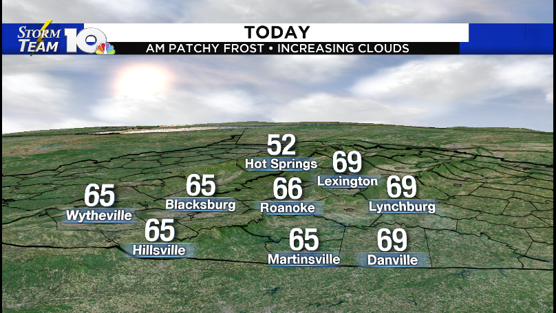
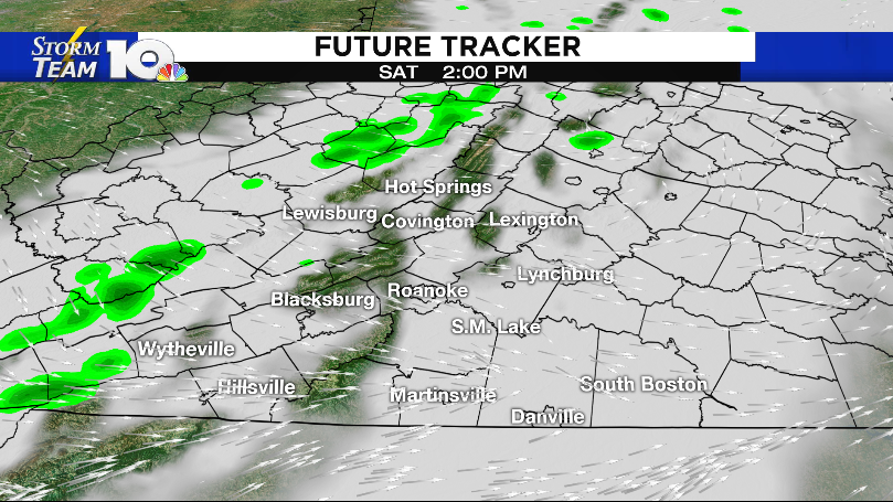
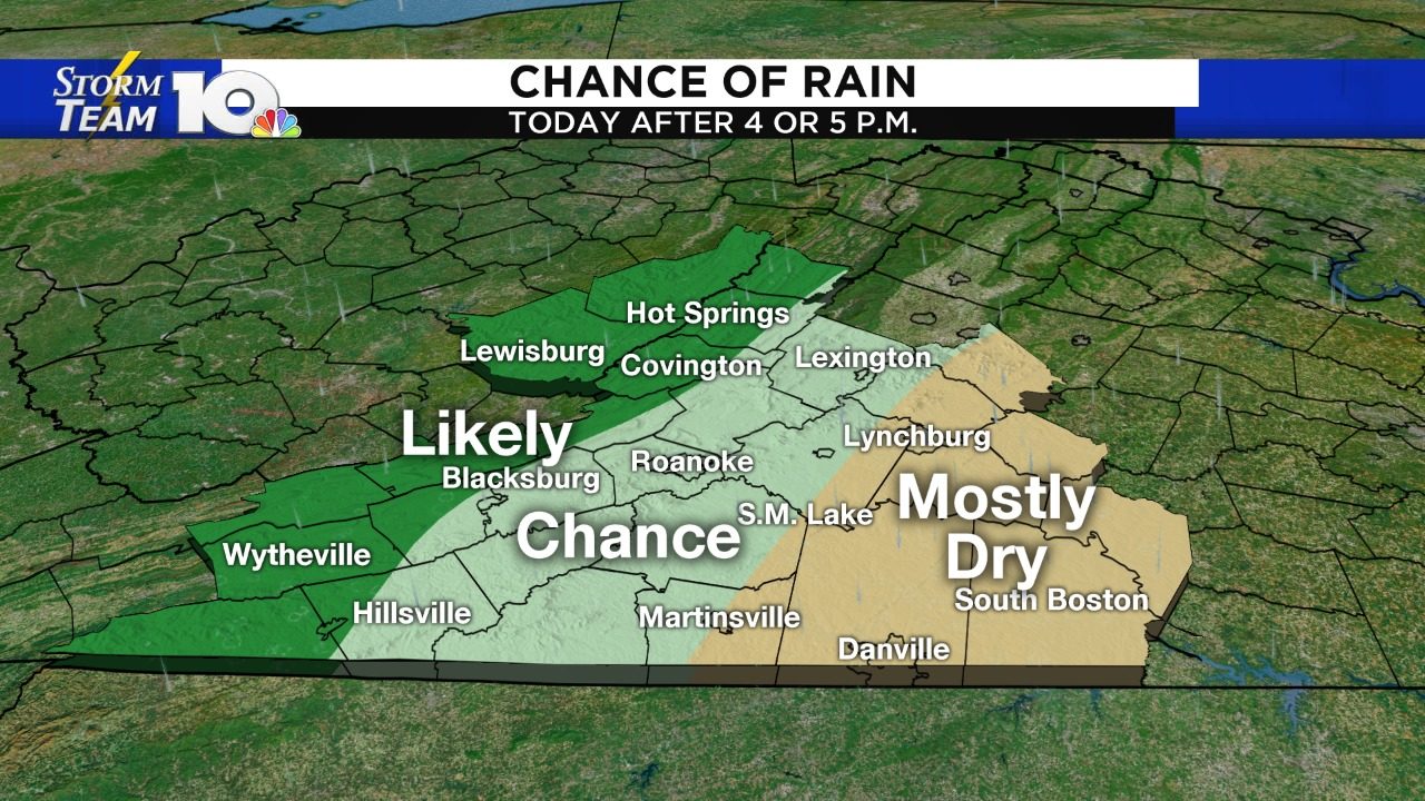
Chilly Saturday morning, patchy frost possible
Read full article: Chilly Saturday morning, patchy frost possibleROANOKE, Va. - Patchy frost will be possible early Saturday morning along and west of the Parkway. Early morning temperatures will begin in the 30s under mostly clear skies. The clouds will increase as we go throughout the day and temperatures are expected to top out in the mid to upper 60s. Tropical Storm Nestor will track south of Virginia, which it will bring us rain late Saturday evening into Sunday morning. The rain will taper off from southwest to northeast Sunday morning and most of us will be dry near noon.

Cooler Sunday, light showers possible
Read full article: Cooler Sunday, light showers possibleOtherwise, expect a few light rain showers along and east of the Parkway. The clouds will begin to decrease west to east late in the afternoon, and we all may see a little sunshine before sunset. It'll be a cool night with overnight lows falling into the 40s and lower 50s under fair skies. Our next cold front will bring us the chance of scattered showers late Tuesday and Wednesday. It will also bring high temperatures crashing down into the 50s and lower 60s by Thursday.
Weekend boundary to bring cooler air
Read full article: Weekend boundary to bring cooler airROANOKE, Va. - A cold front will pass through southwest Virginia Saturday and bring a mixture of sun and clouds to the region. A few spotty rain showers will be possible, with the best chance along and west of the Parkway near midday. The boundary will stall-out nearby, resulting in spotty showers overnight and into Sunday. The boundary should clear the region Sunday night and clouds will decrease Monday. Another cold front will bring scattered shower chances and a bigger cool-down Wednesday.
"The wedge" puts clouds, cooler air in our region through Tuesday
Read full article: "The wedge" puts clouds, cooler air in our region through TuesdayThis is all thanks to a pattern we know very well around here, called the wedge (aka. High pressure to our north and low pressure offshore both create a wind out of the northeast. That northeast wind essentially banks up against the mountains and creates this dome of clouds and cool air. Temperatures won't move much, meaning we're rocking the long sleeves and/or light jacket throughout the day. Rising air west of the Parkway will help create a few batches of light rain throughout the day.
Warmer than the weekend; rain arrives late for parts of the area
Read full article: Warmer than the weekend; rain arrives late for parts of the areaROANOKE, Va. - After record-breaking heat last week and a cool-down this past weekend, temperatures bounce back a little on Monday. It's not until after 4 p.m. that we see rain moving into the Mountain Empire, New River Valley and Highlands. This is with a cold front that will moving through our area later today from west to east. After our cold front passes through, high pressure to the north and low pressure offshore will wedge in some cooler air and clouds Tuesday. If low pressure can stay close enough to the coast, we may see a few showers around Southside by the afternoon.
Tracking spotty rain showers
Read full article: Tracking spotty rain showersExpect a few passing showers in the morning along with areas of patchy drizzle. A few passing showers will be possible along and west of the Parkway Sunday night. Our best chance of rain will arrive on Monday as a cold front pushes through the area. A few spotty showers are possible in the morning with the best chance of rain arriving in the afternoon and evening. A few showers could linger into Tuesday morning.
Tracking some much needed rain
Read full article: Tracking some much needed rainExpect a few passing showers in the morning along with areas of patchy drizzle. A few passing showers will be possible along and west of the Parkway Sunday night. Our best chance of rain will arrive on Monday as a cold front pushes through the area. A few spotty showers are possible in the morning with the best chance of rain arriving in the afternoon and evening. Temperatures will be staying in the 60s and lower 70s for the work week.

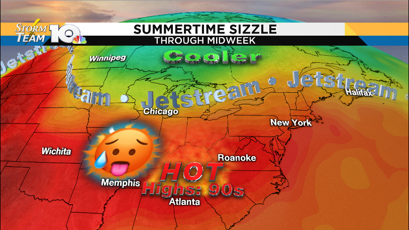
High temperatures nearing 100 in some parts of the area Thursday
Read full article: High temperatures nearing 100 in some parts of the area ThursdayA large, strong area of high pressure sits over the eastern U.S., subjecting us to highs in the 90s Thursday afternoon. We'll be in the low 90s in the NRV, middle 90s in the Roanoke Valley and mid-to-upper 90s in Lynchburg and Southside. Make sure that you hydrate early and often, if you have to be outside for a long period of time. The more emphatic cool-down comes Saturday, when high pressure to our northeast ushers in some fall air. Temperatures and humidity levels rise a little bit ahead of our second cold front of the week.
Spotty storms Thursday afternoon; up-and-down temperatures beyond
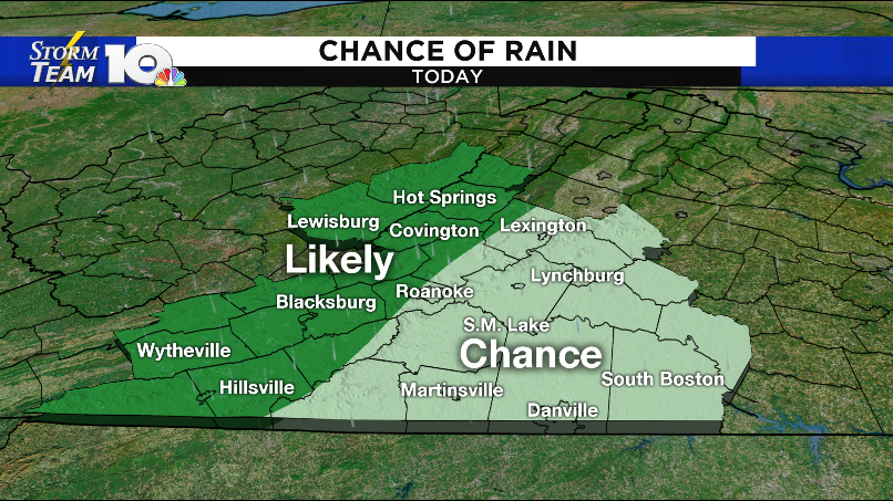
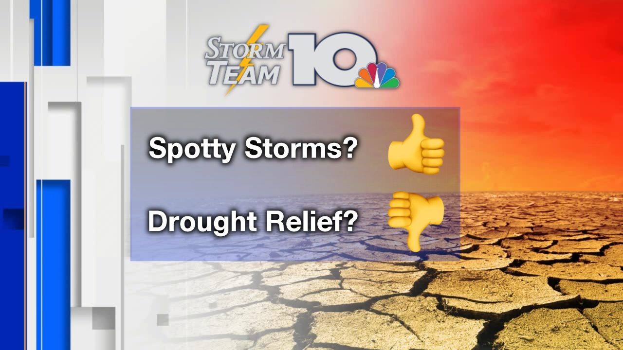
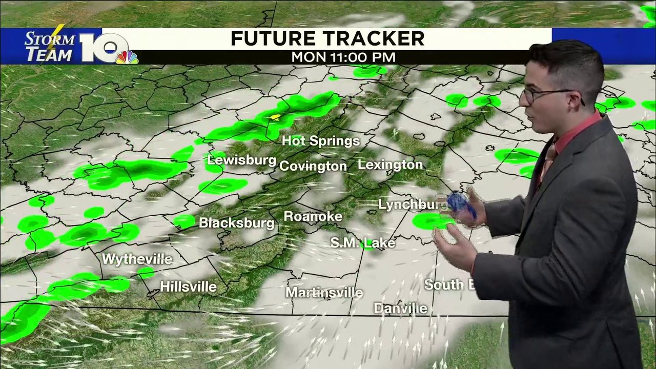
Read full article: Spotty storms Thursday afternoon; up-and-down temperatures beyondWe're quick to get happy over any chance of rain, but Thursday won't offer the widespread rain we need. A front moves in from the west, teaming up with some heat and humidity, to give us some spotty showers and storms after about 2 or 3 p.m. This will also keep any shot of rain south of here. Again, this is bad news for our drought but good news for Hokies fans going to the game Friday evening. A different front nearby will trigger hit-and-miss storms, before another minor drop in temperatures by Monday.
No relief, heat wave continues for the work week
Read full article: No relief, heat wave continues for the work weekSunday afternoon temperatures will soar into the mid-90s under partly to mostly sunny skies. Heat index values east of the Parkway will be in the upper 90s and lower 100s. Spotty afternoon shower and thunderstorm chances continue for the beginning of the work week with temperatures topping out in the low to mid 90s. Thunderstorm chances increase midweek as a cold front begins to work into the region. This will also bring some relief to southwest Virginia with highs cooling back down into the 80s.
Hazy, hot and humid weekend
Read full article: Hazy, hot and humid weekendROANOKE, Va. - Brace yourself for a hazy, hot and humid weekend. There is the chance of an isolated pop-up afternoon storm east of the Parkway and the precipitation will end by sundown. Afternoon temperatures will top out in the mid-90s, especially for locations east of the Parkway. An isolated afternoon thundershower is possible but most will remain dry. Spotty shower and thunderstorm chances continue for the beginning of the work week with temperatures topping out in the lower 90s.
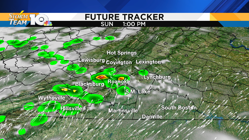
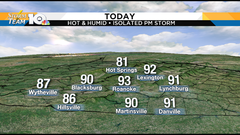
Hot, humid Sunday with spotty afternoon storms
Read full article: Hot, humid Sunday with spotty afternoon stormsIf you factor in the high humidity levels, some locations east of the Parkway will feel like the lower triple digits. Scattered showers and thunderstorms will develop near lunchtime and continue through the afternoon. An isolated strong storm containing damaging wind gusts and heavy downpours cannot be ruled out. A cold front will bring scattered showers and thunderstorms to the area Monday afternoon and evening. The precipitation will continue into Tuesday morning and then big-time relief will be upon us.
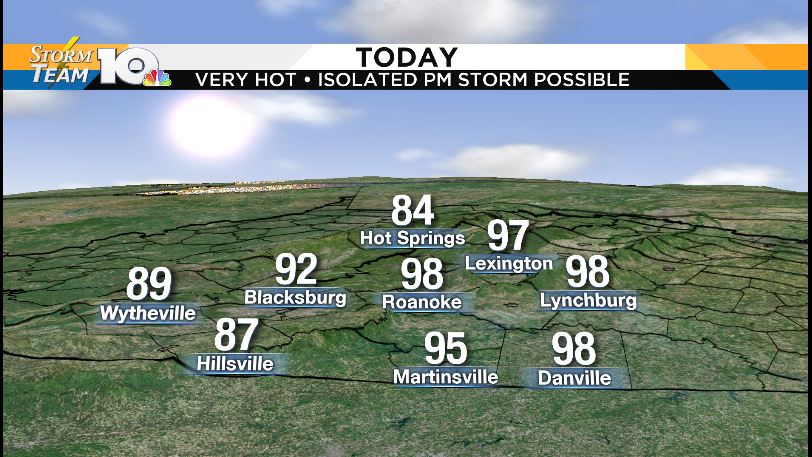
Scorching hot weekend ahead
Read full article: Scorching hot weekend aheadROANOKE, Va. - It is going to be a scorching hot weekend. Saturday afternoon highs will quickly soar into the mid to upper 90s under partly to mostly sunny skies. If you factor in the high humidity levels, itll be feeling more like the triple digits for locations east of the Parkway. An isolated afternoon storm is possible but most locations will remain dry. Spotty showers and thunderstorms will develop Sunday afternoon with the best chance for locations along and west of the Blue Ridge.